Before leaving Aitutaki we decided to participate in a lagoon cruise and yes the sun was out so we could admire the different shades of blue of the lagoon and it’s motus. We visited Akaiami motu, once a refueling stop on the famous Coral Route in the 1950’s-60’s for waterplanes on their route from New Zealand to Tahiti. We had a barbecue lunch on One Foot Island, awarded one of the leading beaches in Australasia region. We did some snorkeling but were disappointed after being spoiled in the Tuamotus. The lagoon cruise is definitely a must if you want to see all aspects of Aitutaki.
We booked one evening at a resort for a typical Cook dance performance.I was amazed by the way they handled the fire.Our daily visitor in Aitutaki, the reef heron.The lagoon of Aitutaki on a sunny day.cruising the Aitutaki lagoon on a beautiful day with all the shades of blue…View of “one foot island” where we had a lunch barbecue.I do not think it can get more paradise-like.The snorkeling was not so great compared to what we have seen in the Tuamotus but I did manage to take a picture of the White barred triggerfish. You see them a lot in French Polynesia but they are very fast…We could walk from the sand spit to One Foot island.Last beautiful sunset in Aitutaki, time to leave for Palmerston.
June 25, Sunday , we checked the weather and the wind was good so it was time to leave for Palmerston. Bill’s wife (whom we met in the visitor centre) asked if we could take “something” for her family to Palmerston which we gladly accepted. This “something” turned out to be 16 cartons with bananas and papayas and 4 more bags with watermelons, a suitcase, and a bag of candy … a good thing we have a catamaran and lots of hull space! Two days and 236NM later we arrived at lunch time in Palmerston and took one of the moorings guided by Bob Marsters.
The streets in Palmerston with a view of the original house of William Marsters (next to the church), still standing after several cyclonesView of the beach of Palmerston. Every morning somebody will sweep and makes sure the fallen leaves and dirt is collected.
The history of Palmerston is unique. In 1862 William Marsters from Lancashire settled here with his 3 wives and 26 children. He divided the island and motus into sections for each of the 3 families with strict rules of intermarriage. Today 58 people are living on the island all connected somehow to William Marsters, except for some people employed by the Cooks Government (nurse and teachers). The island has no airport and the supply ship only comes when it is profitable to come by, so once every 2-3 months. Since 2015 they have 24hr electricity supplied by a solar power station sponsored by the Cooks government. Before that they only had a generator who supplied 6hrs electricity in the morning and 6hrs in the evening. There is internet and one TV channel since 2014, so life is changing….
The welcome was incredible. We were invited into Bill’s house for lunch and after saying a blessing we had rice, fish, lamb, corn and tarrot root. For dessert there was ice cream. Not only the first day but every day we were invited for lunch prepared by Bill because his wife was in Aitutaki with one of their daughters, Caroline. The other children, Juliana (16), Ngariki (14) and the youngest son (10) ate after returning from school around 2-3PM. Ngariki gave us a tour of the island, showed us the school (15 children between 6-18 years old), the infirmary with an enthousiastic nurse from Fiji, the wreck from the Riri and the old cemetary. There are no paved roads on Palmerston but the sand roads are raked clean on a daily basis. No cars but at Bill’s house they had 2 motorcycles and we did see one quad…times are changing. There are no stores on Palmerston and thus everything has to be ordered from Rarotonga to come with the supply ship. Every house has serveral huge freezers to make sure they have enough food till the next ship arrives. Most of the families live from fishing. They sell their fish (mostly parrotfish) to hotels and cooperations in Rarotonga for about 15NZD a kilo. But they remarked that there is less and less fish to be caught…is this temporary or a trend? They are aware of the climate change and see more and more coral bleaching because of the warm water. The population of Palmerston is aging. A family with 9 children had just left the island a couple weeks before. Although Palmerston is for some a paradise I can fully understand that for others (especially youngsters) this is too limited and they move to NZ, Australia or Rarotonga in search of a “better” life. A lot of them do come back for visits or to grow old.
The little but well supplied “infirmary’ of Palmerston.We are so happy we met with the teachers Josh (US) and Melissa (South Africa). Their contract ends in December in Palmerston. I hope they stay in contact and let us know where their next assignment will be.The grave of the founder of Palmerston, William Marsters.Picture of the primary school, from age 6 to 10.Juliana, on her 16th birthday, playing the guitar at dance practice.The happy girls from Palmerston.Dance practice at the school.Bill Marsters (left), next Juliana (16), Stefan and Bill’s son Ngariki (14).A last picture before leaving with Bill and his family. His wife and one daughter were in Aitutaki.
The unconditional generosity and “do good” attitude of the Marsters (In Flemish we say “doe wel en zie niet om”) is so remarkable that this short stop of 4 days will be fondly remembered.
On Tuesday June 13, we decided to leave Bora Bora and make our way to Maupiti as a possible stop on our way to Aitutaki. Only when we got there around 4PM the swell from the south was about 2M and breaking waves across the pass made it, in our opinion, too dangerous to enter. Once entered we also were not sure how easy it would be to leave Maupiti again and we wanted to get to the Cooks. So we continued sailing… The sea became very rollly during the night and with waves of about 3M, winds of 15KTS I was getting sea sick. My body was not used to this anymore. I had not taken anything because I was sure I would be able to do without. I guess not. After being really sick I decided to take one of the pills just before going for my 3HR sleep and sure enough I woke up feeling much better. I continued to take them every 12hours till we got to Aitutaki and felt fine. Hopefully I can get to Palmerston without one.
“waiting” for the wind to pick up in Bora Bora Kai Mai Marina with free wifi…Enjoying the “waiting” in Bora with Happy HourLunch at Bloody Mary in Bora. Another celebrity name they can add to their list!The captain getting diesel, 310L at .78cents (tax free). Still 240EUR though.
We arrived after 4 days of sailing on Saturday morning around 8AM but had to “heave to” twice during our trip so we would not arrive in the dark at the pass. We were not sure if we should enter right away since we knew it was low tide and the water was leaving the lagoon at a rapid pace. The Captain did not want to wait another couple hours so I went upfront ready to drop the anchor in case it was needed and we pushed Sanuk against the current of 5KTS into the lagoon. Our depth meter said “0”, a good thing Stefan did not mention this while going in or I would have flipped! We are now anchored in the little harbour of Arutanga in a depth of 2M and tied to 2 palm trees. We have been here a week and no other yacht has arrived here. This is definitely not an easy pass to navigate through.
Sanuk anchored in 2M deep water in the little harbour of Arutanga, the main village on Aitutaki. About 2000 people live on the island.
Aitutaki is an “exclusive” tourist spot mainly for Australians and New Zealanders looking for a winter break. In June 2010 the island was nominated “the world’s most beautiful island” by the founder of the Lonely Planet Guides. Unfortunately this week the weather has been grey and rainy till thursday. Not fun when you are only here for the week in an expensive hotel.
Most of the Cook Islands (15) were discovered by Captain Cook, hence the name but the first European to set foot in Aitutaki was Captain Bligh in 1789 with the Bounty, just a couple weeks before the mutiny. The Cook Islanders are polynesian and the main language is Cook Island Maori but they all speak english with a heavy NZ accent. The Cooks islands are independent since 1965 but affiliated with New Zealand for defense, foreign affairs and finances. Cook Islanders are NZ citizens.
Aerial view of Aitutaki. Picture from internet. We are on the far side in the middleWe hiked to the highest point on the island, 124M, Maunga Pu, to enjoy the beautiful view on the lagoon.There are about 15motus in the lagoon. Kite surfing is very popular on the island.We visited the Aitutaki Marine research centre, they protect the colourful clams from the lagoon.They are eaten by humans, some fish and turtles.The Cook islands Christian church is the oldest one in the Cook Islands and was built in 1828.No dogs allowed on the islands but pigs everywhere.No cemetary on the island but graves along the road and in the gardens.Enjoying a very good evening dinner at Cafe Tipuna with our feet in the sand. We got there by bicycle after being lost for 15min in the complete dark. No streetlights or moon…View from the pass with Sanuk on the right and the first Cook islands Christian Church on the left.
While the weather was not so great we enjoyed walking and bicycling around the island. We even had to wear a sweater during the evenings. Yesterday we took out Fiipper to tour the lagoon but the wind and cold water (only 22 degrees) made us turn around. Tomorrow we have booked a lagoon cruise with a barbecue on “One Foot Island”. It looks like it will be a sunny day.
We have checked out today (Friday) since there are no custom officials working during the WE. We paid 220NZD (about 140USD) departure tax and anchorage fee of 5NZD per day included. In French Polynesia, part of the EU, we did not pay anything…
Wednesday May 3th in Apataki. It has been almost 2 weeks since we arrived with the Cobia 3 in Apataki and slowly but surely we are getting Sanuk ready for the water.
We left Auckland on Monday morning April 17th to arrive in Papeete on Sunday afternoon the 16th since we crossed the international dateline (IDL). The IDL is an imaginary line from the North Pole to the South Pole and demarcates the change of one calendar day to the next. NZ is West of the IDL while French Polynesia is East of the IDL. It was like going back in time and so we got to experience Easter sunday twice! When we will sail to Fiji we will again cross the IDL but then we will loose one day.
Stefan had arranged a pick-up at the airport from the hotel and indeed we saw our name on one of the many cardboards at the exit of the airport. What a nice feeling it was, back in 28degrees celsius, humid but I did not mind and lots of friendly faces with flowers in their hair. They were surprised when they saw our amount of luggage! No, we are not a normal tourist in Polynesia! We had 5 bags of each 23KG and 2 smaller bags of each 12KG…but the van was big and we got everything loaded. Papeete was like a ghost town since it was Easter but at least the “Roulottes” (foodtrucks) were open and we were happy to have dinner there. We decided on “Galettes et Crepes Bretonnes” :-)! The wait was soooo long (almost 3hours when we had eaten) but we enjoyed being in the atmosphere, watching the tourists and Tahitians enjoying their Easter with family.
The next day we decided to rent a car to get all the shopping done (only boat stuff and food 🙂 ) to take with us on the Cobia 3. Unfortunately all the stores were closed except for Supermarket Hamuta, they were open till noon, we got there at 11.30AM but they let us shop till 12:30 and they delivered everything to the Cobia 3 the next day . Luckily we also found the Carrefour open and got another 3 boxes filled with food… For dinner we met with our friends from Jambote, Simon-Pierre and Marine, who had just arrived in Marina Taina. It was so good to see them back and tell our stories ! Life is wonderful!
Important cargo for Apataki. All our luggage and boxes went into this crate for Apataki.
Not a luxury cruise but at least we have a bed. And Jesus!
We had made reservations for the Cobia months ago but were kind of nervous since we had not paid anything and did not know what time the Cobia would leave. Stefan left at 7AM to go check it out and sure enough at 7.30AM the office was open and our names were on the list!! We paid 7000XPF per person (about 70EUR) and were told to bring our luggage by 11AM. Stefan knew where to get all the things he needed so in an hour he had all the boat stuff and we could leave the hotel by 10AM with all our bags and boxes. We paid another 7000XPF for all our luggage. (more than 150KG!!). We put it in the crate for Apataki and left to return the car just in time! We had a couple hours left to spend in Papeete and by 2.30PM we had to be back at the Cobia 3. I could not believe how smooth it all went! This was great! The Cobia was definitely an experience! We had a bunk bed :-), but there was no real place to sit….so we could only lay down :-(, and the journey took 34hrs. Because of the high waves (4m) I got sea sick :-(, luckily after 8hrs I felt better! There is no food on the Cobia, you have to bring your own food and water. I was too sick to eat the croissants we had. The Tahitian we shared our room with offered 2 apples (they really share soo easily) and I was happy to eat those. We arrived at 2AM in the morning at Apataki village and I cannot say how happy we were to see “Pappie” from the Carenage waiting for us!! We loaded all our stuff in the pick-up truck from Alfred and left for their house in the village where also “mamie” was waiting for us. We took a quick cold shower and went to bed for the remainder of the night. At 9AM in the morning we loaded everything in Alfred’s motorboat and made the trip to the Carenage. We arrived soaking wet (from the waves) but happy to be back “home” and see Sanuk!
View from Sanuk on the carenage and the lagoon in the backCould not dream of a better place to have the boat out of the water.Now we only have to unpack everything ! Good to be back home.Cleaning and oiling the teak toprail.Scrubbing the teak floor.
We have been busy fixing, painting, replacing, rearranging and socialising and hope now that we can get Sanuk in the water on May 8th or 9th. It is clear that a boat needs to sail and having it on the hard this long (almost 6months) is not so good. There was a corrosion on the connecting bar between the two rudders …..with patience, acid and oil they are now cleaned and like new and this solves also the steering problem we had before. The bottom is halfway painted, I am now waiting for an extra pot to arrive on the Cobia tomorrow. I should be able to finish the other half the latest by sunday. The Honda motor of Flipper had to be cleaned since we forgot to drain the gasoline when we left. It got sticky and plugged up the carburator. It sounded fixed but Stefan wants to test all the motors before going in the water. The oil from the generator is replaced, the trampoline is replaced with a new one, all the teak wood is cleaned and oiled, the chips in the gelcoat are fixed, and our fix it list is getting smaller.
Putting on a new anti-fouling coat on Sanuk’s bottom. Anti-fouling paint is important because this prevents the growth of mussels, algae etc on the hull. These growths can affect the performance or durability of the boat.
A job well done by the admiral :-).The captain at breakfast.Pua (meaning pig in tahitian) the mascot of the carenage. He behaved more like a dog than a pig. He could roam around the carenage freely until one day she ate “mamie’s” flowers…then he was to stay in his cage.
The hardest part was working in 32degrees celsius and high humidity (70%) so we had to make sure to get up as early as possible (still not my strongest point 🙂 ) and from 12 till 2PM it was siesta time. Too hot to eat but we are drinking liters of water! Luckily we have the sea close by and a shower (cold only) with unlimited water supply !
Gaston and Valentine from Anse Amyot came visit and were always ready for a party with singing and good food.Dinner with all the cruisers at the carenage. An international group from Mexico, France, Madagascar and Belgium.Valentine playing the ukulele and singing.
The people from the carenage are all very friendly and we have been invited a couple times to have fish barbecue with them. The fish is put ALIVE on the barbecue and there is rice and homemade sweet and sour sauce. Very yummy. The first time they played the ukulele and guitar and sang while we were having dinner under a starry sky! Does it get any better?
Getting Sanuk ready to be put back in the water. 15 Ton to be carried on the trailer is a delicate operation but Tony and his team know what they are doing.Also in the water there is preparation to be done.Alfred watching over Stefan while he is cleaning off the last piece of tape.Nini putting on some last minute anti-fouling under the keel.View from Sanuk, almost in the water.Saying goodbye to Ryan and Natasja from “Cheeky Monkey”. From left to right, Natasja, Stefan, Manu, Ryan, William, Nini, Tony and his mom Pauline.Stefan saying goodbye to the nurse shark. Watch those feet…
April 17th, Papeete, Tahiti, it feels good to be back in 28degrees temperatures and closer to the boat! Our shopping possibilities were limited because all stores were closed because of Easter monday, except the Carrefour supermarket and a chinese supermarket where we could find the foodsupplies to take to Apataki tomorrow on the Cobia 3 !
Flashback to March 26th,2017: We did not stay very long in Dunedin since time was running out and we still wanted to see more of the East Coast.
We made a quick stop to see the Moeraki Boulders and met a Belgian working at the cafetaria there. The Moeraki boulders are large, spherical boulders on Koekohe beach. They are made out of mud, silt and clay cemented by calcite.The large boulders, 2m in diameter,are estimated to have taken 4 to 5 million years to grow !
We continue driving to Mount Cook village in the rain and low clouds 😦 and spent a day at the Sir Edmund Hillary Alpine Center watching a 3D movie on Mount Cook, a documentary on the local mountain rescue team and the digital dome planetarium.
A bronze statue of Sir Edmund Hillary looking at Mount Cook! The day we arrived it was sooo cloudy and rainy that you could not see any mountains in Mount Cook national park! Sir Edmund Hillary is a famous and admired New Zealander not only because of his achievement, his ascent of the Mt.Everest in 1953 but also because of his humanitarian work in the villages of Nepal.
The next morning it was not raining but there were still a lot of low hanging clouds over our campsite. We were not sure what walk to do and decide to go to the outlook and take a decision on the way. Rainjackets, pants and backpack with some water we go on our way. When we come to a marker with the several walks we decide to take “Sealy Tarns”, only 5.2KM(one way), 3-4HR return walk, we think that is not too bad… Later we read the description of the walk,”The Sealy Tarns Track begins gently until you reach the foot of the Mueller Range. The track zigzags steeply up to Sealy Tarns.” The track consists mainly of 2200steps which have to be climbed! This was definitely one of the most challenging walks we did and we were not prepared! But the reward was incredible…
After 45min of walking, climbing and huffing and puffing we get this view! Above the clouds…it is really magical.You can see Mt.Cook all the way in the back.Taking a rest and enjoying the view.The Maoiri name for Mt.Cook is Aoraki, meaning “cloud piercer”, could not find a better one.Reaching the Sealy Tarns. A tarn is small mountain lake or pond.While we were eating our granola bar, we did not bring anything else, we watched the clouds disappear and a beautifull view unfold. Mt.Cook is showing all its beauty.The glacial lakes at the bottom with the last clouds evaporating by the sun.
The return walk was not easy as well since it was so steep our legs were shaky. But we enjoyed the scenery so much that we did not care and arrived all happy under blue skies at the campsite. We drank and ate something. Felt stupid not to have prepared this walk better, we had no suncscreen nor a hat with us …we should know better, in the mountains the weather can change rapidly! This walk was definitely one of the highlights of our trip to NZ! We continued our route out of Mt.Cook National Park (also UNESCO world heritage) and went to Tasman glacier view and Tasman Lake…
Tasman glacier with Tasman Lake.You can take a boat ride in Tasman Lake and see the icebergs in the water up close.In the early 1970’s there were several small meltwater ponds on the Tasman glacier but by 1990 these had merged into Tasman Lake. Tasman Lake has quickened the retreat of Tasman glacier.
The scenery along the drive from Mt.Cook village to Lake Pukaki and Lake Tekapo is really incredible.
Lake Pukaki (glacial lake)and Mt.Cook in the back.Church of the Good Shepherd and lake Tekapo in the back. It was the first church built in the McKenzie region in 1935.
In the visitor centre of Omarama they told us to go see the Clay Cliffs and the pictures convinced us to go. This is definitely a hidden gem in NZ! We did not have the blue skies which would have made it even more beautifull but they were incredible. We had to drive 12km on unsealed road and pay 5NZD a the gate because they are on private property, but it was worth it!
The cliffs were formed 2 million years ago.We were there all alone which made it even more special.
We leave the cliffs just in time to stop by a salmon farm and buy smoked salmon for aperitive and fresh salmon filet for the barbecue!
The next day we start out with rainy weather but as we continue our drive the clouds give way to sun and by the time we arrive at Rakaia Gorge it was perferct! We see a perfect camping spot but decide to do the Rakaia Gorge walkway first since the weather was so nice.
It is a 10,2km walk (return) along the top of the Rakaia Gorge and the views are spectacular.The Rakaia river making its way through the gorge.
We lost our good camping spot but were happy we did the walk under blue skies as the next day it was drizling again…
Because we did not see any penguins nor an albatross in the Otago Peninsula (Dunedin) we decided to drive along the coast to Oamaru because the Rough Guide said this is a unique place to see the Yellow Eyed Penguin and the blue penguin since there is a colony within walking distance from the town centre!
Would they really cross the street…The yellow-eyed penguin or hoiho (Maori) is native to NZ.They are endangered and considered one of the world rarest penguin species.Their estimated population is only 4000.You can only spot them early in the morning when they leave their burrow to go fishing (not a good time for us 🙂 ) or in the late afternoon, in this case 5.30PM when they return from a day fishing. NZ is very protective of the penguin and you cannot go on the beach or near at certain hours of the day so they do not get frightened and return back to sea.
We then decided to go see the blue penguin but we were informed that they only show up around 7PM, almost dark…We were at the rendez-vous a little after 7PM together with a lot of other penguin enthousiastics. We waited and waited, Stefan got a blanket, it was cold and windy, started to drizzle but we persevered and around 8PM a whole bunch came tumbling with a wave on the beach 🙂 Really funny how they then walk up the hill to their burrows. Unfortunately because it was already dark and you can not use a flash and they are far away I did not get any good enough picture…The blue penguin (Korora) is the smallest of the penguins. Cold and wet we returned back to Burnie, happy we did at least see the penguins!!
Our drive to Chrischurch was with continuous beautiful scenery and very variabel weather. Summer was over, leaves were turning to yellow and orangy colours and a lot already falling. We camp at Lyttleton harbour and the next day we decide to drive to Akaroa along a scenic route, Summit Road which traces the 600m high Akaroa crater rim. We stopped many times to take pictures and walked 30min to a viewpoint, all just in time to see the clouds roll in.
Akaroa is a little town with french roots. The first settlers came from France and a lot of the street names are still in french. It is a popular KIWI holiday destination.
The Akaroa Lighthouse Preservation Society moved the lighthouse from the Akaroa heads close to the town centre in 1980. It was built in 1879 and one of the few wooden lighthouses remaining.We made it back to the town centre before the downpour.
Arriving in Christchurch was a surprise. We could not believe the destruction still visible from the earthquake that hit the city in February 2011! 6 years later and still so many buildings waiting to be torn down, rubble and cranes everywhere. Stefan felt sad seeing the city like this while I could sense a dynamism in the newly created parts of the city. We did not stay very long because it was already April 3rd and we had to be in Auckland by April 8th to show Burnie to a potential buyer.
Earthquakes occur very frequently in NZ because it is situated in the collision zone of two plates, the Indo-Australian and the Pacific tectonic plates. About 14000 earthquakes occur in and around the country each year and about 150 to 200 are big enough to be felt. We did not feel once the earth rumble.
The 2011 Christchurch earthquake registered 6.3 on the Richter scale and was centered 10KM of the centre of Christchurch. 70% of the CBD (Central Business District) buildings have to come down.The Christchurch cathedral was severely damaged and the Anglican church decided to demolish the building and build a new one but this led to many protests and legal action from various groups. This litigation is still going on and so the church still stands…the tower was destructed in 2012.The Canterbury Earthquake natiional memorial was unveiled on February 22, 2017, just before we visited. 6 years after the destruction…185 people of more than 20 countries died.The new Christchurch, which is being marketed as “greener, more compact, more accessible and safer”, will cost in the region of NZ$40bn – almost 20% of New Zealand’s annual GDP.The Chalice still stands! It was built in 2000 and survived the 2011 earthquake.It is designed by New Zealand artist Neil Dawson, and is made up of forty-two leaf patterns featuring different native plants.The Paua House was a tourist attraction in the southern New Zealand town of Bluff, but now on display at the Canterbury Museum in Christchurch. The house was owned by elderly couple Fred and Myrtle Flutey, who built up a massive collection of ornaments made from the iridescent shells of the paua. They continued to do this for 40years and welcomed visitors from all over the world. When they died their grandson gave their collection on loan to the Canterbury Museum who made a replica of the house. NZ kitsch at the extreme but such a nice story!
We hurried back to Auckland passing by Wellington in the pouring rain from the storm Debbie and managed to sell Burnie to a french couple travelling for 2months in NZ. We rented a little camper and drove north of Auckland to Whangarei. Visited Aislado (NZ) in Marsdens Cove Marina, An and Ivan on Vaguebond in Town Basin at Whangarei. Drove to Russel ,where we had an excellent meal at the Duke of Marlborough, and stopped in Waipoua Kaori Forest to see the largest living Kaori tree from NZ. Cyclone Cook passed by…but we arrived safely and saturated with lots of nature scenery in our heads at our friend’s house late April 14! So nice to finally have the luxury of staying in a nice house, sleeping in a bedroom, toilet and bathroom next door 🙂 !
Together with Sylvia, Vaughn and Zara at a Thai restaurant on our last night of our trip in NZ.
Thank you so much Sylvia, Vaughn and Zara for your hospitality, help and friendship! We hope someday to welcome you all in Ghent !!! 🙂
April 16th, we are in the Holiday Inn near Auckland airport since we have to be there at 7 AM the next morning for our flight to Papeete ! We have 5 bags and 2 check-in pieces ! Hopefully it will go smoothly 🙂
Flashback to March 19th 2017: The next day was just perfect blue skies and we could admire Milford Sound (Piopiotahi) in all its beauty.We could not have planned any better.
Milford Sound is part of Fiordland National Park, the largest national park from NZ. Actually Milford Sound is a glacialy formed fiord and not a sound. It is 16km long and mostly less than 1km wide. The most prominent mountain is Mitre Peak (1692m) named for its resemblance to a bishop’s mitre.We took a 2hr boat trip into the sound and although we were somewhat disappointed (we are spoiled) it was still beautiful.Stirling Falls thundering down.A sealer John Grono discovered Milford Sound in 1823 and named it after his home port in South Wales, Milford Haven.Standing at the Homer Tunnel taking pictures of the road below. Really an impressive sight!And finally we meet the Kea bird on our way back from Milford Sound ! It is the only alpine parrot and endemic to NZ. It is olive green on the outside but when he opens his wings…I unfortunately could not take this picture but this is what the Kea looks like in flight. He is hiding all his colours under his wings.They are not tame birds but they are very playful and inquisitive and love the interaction with tourists. Stefan finally found a good playmate 🙂Along our way back we stopped to walk the last section of the Routeburn track. The Divide to Key Summit.Gentiana Frigida, I thought they were always blue but apparently in NZ the white variation is common.On our way to the southern tip of the South Island we made a stop at the historic Clifden suspension bridge, one of the longest in the South Island. It was built in 1899 but no longer in use.The coast is wild and beautiful. Even with the clouds and rainy weather we enjoyed getting out and watching the waves.Stirling Point at Bluff, almost the most southern tip of NZ. The anchor chain sculpture disappears in the sea to symbolically connect with a near identical sculpture in Lee Bay on Stewart Island. The sculpture is from Russell Beck.We made 2 short walks at Bluff and finally I managed to take a nice picture from the TomTit! This bird is also endemic to the islands of NZ.The Tui bird singing away, you hear them everywhere but they are not easy to spot. They are easy to recognise by the 2 white feathers in the front.Windswept trees so typical for the Catlins Coast.Curio Bay at the Catlins. The Catlins Coast is one of the least populated areas in NZ.Not a lot of people but a lot of sheep. Although more farmers are now switching from sheep to cows because dairy is more profitable. In 1982 there were still 20 sheep to one NZ’er now it is only 6 sheep. We talked to one farmer who had 30.000 sheep and 1500 cows!Stefan at the bottom of the McLean Falls.The McLean Falls, 22m high. It was great to just sit back and admire…A little further down the road were the Purakaunui Falls…Right near the falls was this NZ woodpigeon or Kereru. Happy to have his picture taken. He chose a good spot right in the sunlight.Stefan found his treehouse 🙂Nugget point with its lighthouse from 1870 still working.Nugget point at the Catlins.Happy it was not raining and we could enjoy the scenery without rainjackets or umbrellas.
While we were in Dunedin we did the self guided street art tour and it was really a lot of fun with great artworks ! Maybe a good idea to have a similar project in Ghent!
Riding Dreams from Pixel Pancho (Italy)Tuatara from ROA (Belgium).Love is in the air from Natalia Rak (Poland)This work is from Phlegm (UK) but I do not remember the title.Even the electric distribution box was painted…
Next blog on our way to Christchurch and back to Auckland.
Here are some tips that I have found that will be useful for anyone traveling in New Zealand for longer than 2 weeks
trademe.co.nz is the site to sell/buy almost anything, including campervans. Just remember that you need a new zealand address to sell anything, and a new zealand address to reply to any listed add. (Any address will do, like a AirBnB or a backpackers hotel). Therefore it pays to put your email and phone number in the ad text itself when you are selling something.
If you travel a longer period, say over a month, it pays to buy a vehicle and then sell it again at the end of the stay instead of renting one. If you are going to be staying long, and you are say over 30, you will appreciate the possibility of standing upright in the van, or of cooking inside. The trick is to buy low and sell high 😉 As the camping seasons progress towards April, it becomes harder to sell the vehicle because there is less demand. The season starts around december.
If possible, get a self contained vehicle. This allows you to freedom camp, and check in to a holiday camp when you deem it necessary (showers!). We found that almost nobody with a small campervan uses the portable toilets such as these:
but instead finds a free campsite with a toilet. These sites are almost always for self contained vehicles only.
When you buy a used vehicle, the buyer can buy it on condition of an inspection. This is a very good idea, even if it costs 159NZD at AA, because it will be a very strong bargaining tool. I compare it with going with an 80 year old to the doctor for a complete evaluation: Hm, the knees are weak and near the end of their functional lifetime, the hip needs replacement, the eyesight is only 50%, …. The final sale price will reflect some of these problems, or have them repaired by the seller. Or you may not buy the car at all. (Did I report that we did not do an inspection when we bought Burnie, but had one done when we sold him?)
The north island is warmer than the south island. So depending on the time of year, you may explore first the North or the south island. If you only have a limited time, then I prefer the scenery of the south island. Queenstown is an ideal basis for exploring the majority of sights to see in the south island, but of course it is better to just drive around and do all the sights…
Get the free campermate app available for iphone and android. It lists all the campsites, point of interest and much much more. Read the comments left by the users, it clarifies a lot and gives up- to-date info. I have been told that there is a similar app from the nzmca. The disadvantage is that everyone with the app will tend to visit the same places, but that does not weigh against the wealth of information that is inside the app, and all of it offline accessible.
Get a good prepaid phone data plan. These tend to fluctuate in value, we had one from The warehouse Mobile that got us up to 3 Gigabyte per month for 12 NZD, but that was no longer available towards the end of our stay. In general, Spark and The Warehouse Mobile have good deals. Spark has wifi booths in many places (they are indicated in the CamperMate app) where you can download 1Gb/day for free.
Use the libraries as a wifi and recharging station. They are open for extended periods, are free and the people are very helpful.
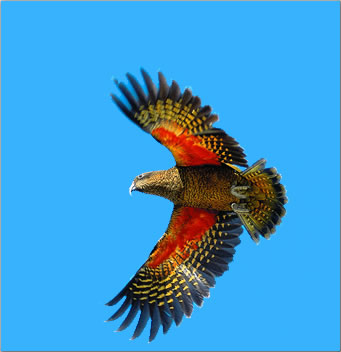
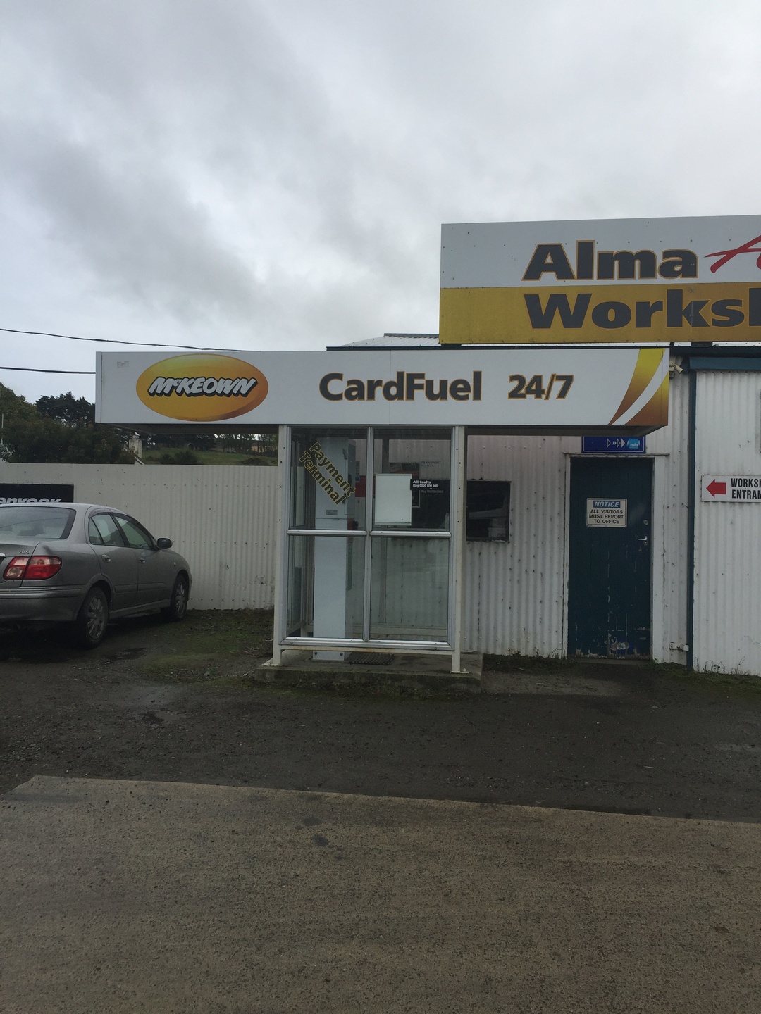
In the south island, here is the best kept secret for saving money: get petrol or diesel at the McKeown stations. They are unmanned credit card stations, but their diesel was 1.009 dollar, when the caltex next door was 1,309 NZD! Many kiwi’s do not know about this, don’t ask me why. They have an app also that works offline. They are affiliated with Caltex, but forget those, they are the same price as everybody else, and play the “today 6 cents off” if you have a AA card (see my previous blog rant about this) . The app is only available in the Apple NZ store but since it does not cost anything, there is a way to become a member of the NZ store without a NZ credit card, here is how. There are enough McKeown gasstations in the south island that you can usually find one near to where you are. There are some non covered areas, and for that you will need to look at the next tip.
Now that you are a member of the NZ app store, you need to download another necessary item: Gaspy (Gas-Spy). It allows you to search for the cheapest gas station in a radius around you. It is necessary in the North island where there are no McKeowns. This app does not work offline, so you need mobile data.
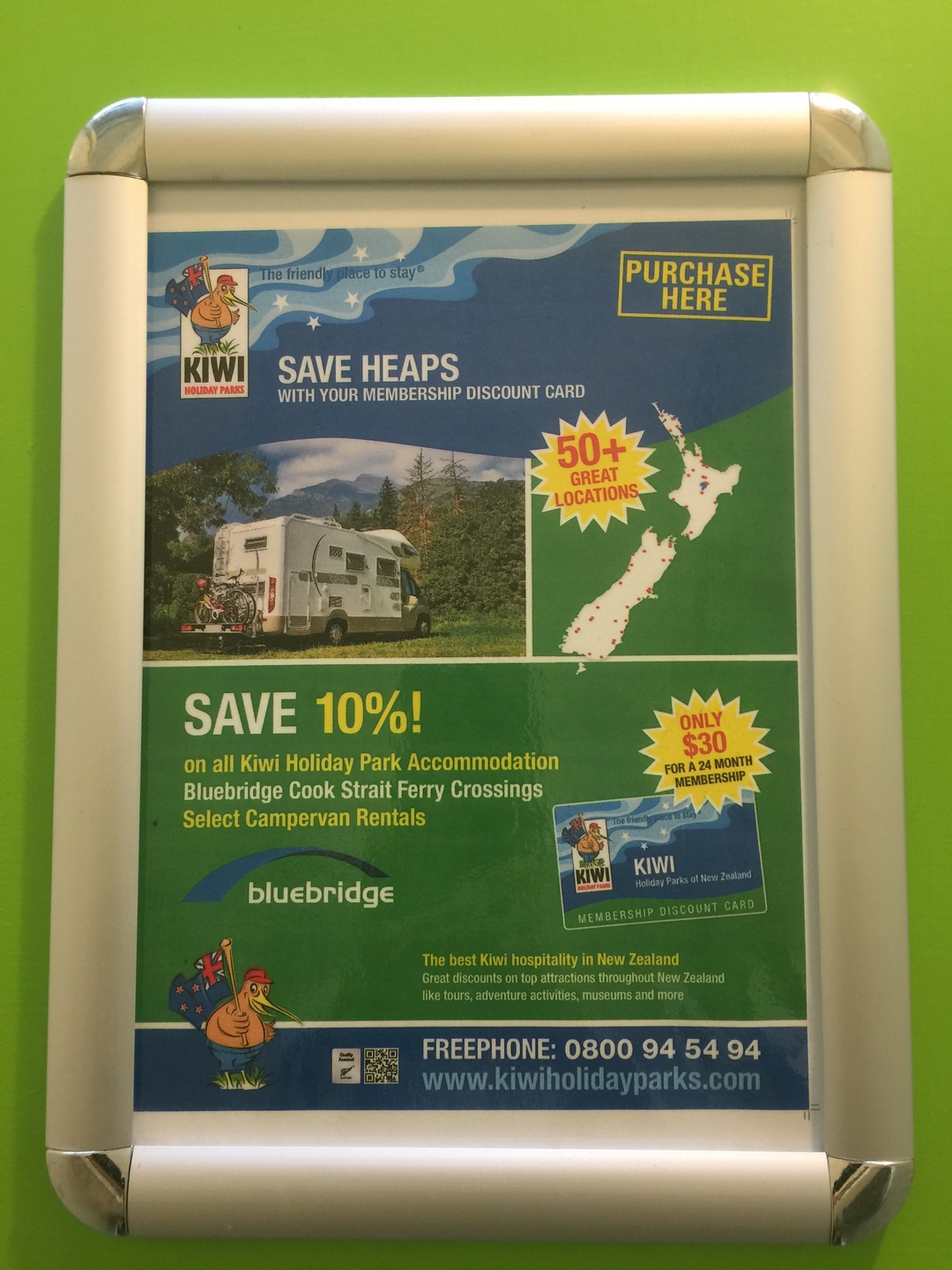
If you cross the channel between the North and South island with your van, it may pay to get a card from one of the two camper places: Top 10 Holiday Parks, or Kiwi Holiday parks. They each are good for 10% off on the ferry. For Top 10 parks, you get 10% off your stay at the park, extra wifi and price reductions at local businesses. It costs 49 NZD. The Kiwi holiday park card is 30NZD and gives similar discounts. If you stay every 3 to 4 days in a holiday park like we did, either card pays for itself. Also both cards are valid for two years and are also accepted in Australia by associated members. More here and here
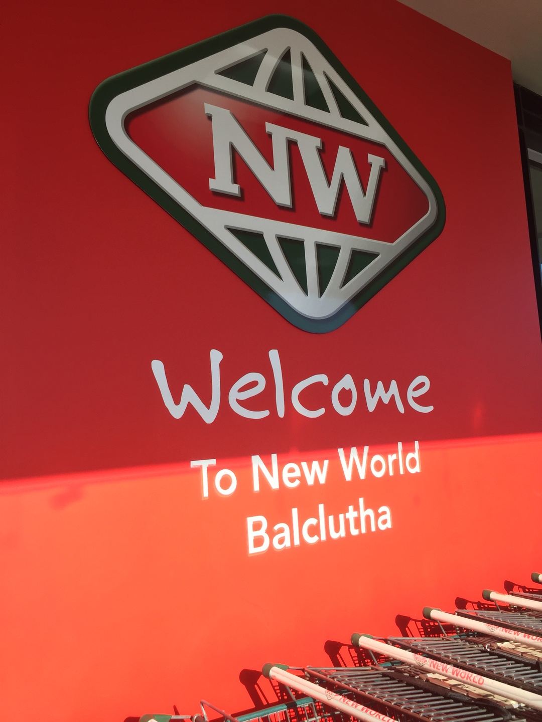
Get the customer cards to save on buying food in the foodstores. The big ones are Countdown, New World, Pak ‘n Save (no card) and then the smaller Four Square (no card). They have all incredible opening hours, usually till 9pm or later, every day! They all still throw plastic bags at you like the is not enough plastic in the world already, except Pak ‘n Save.
Yes, there is such a place as Balclutha
A tip about avoiding driving on the wrong side of the road, the reason for up to 30% of accidents in NZ: The driver always sits closest to the middle of the road. I found that once you are on your way (on the correct side of the road), there are few opportunities to make mistakes. There are plenty of signs that help you conquer difficult situations such as roundabouts. The problem is starting off correct after a stop.
Learn to understand how Kiwi’s drive. They drive quite different from European drivers. For example, they do not want to overtake you unless they have a clear line of sight of about a kilometer. Even if you slow down to like 40, with nobody coming from the opposite direction, some will still stay behind you. Luckily there are many passing lanes where the road goes from 2 to 3 lanes for a kilometer or so. In contrast, the trucks always drive at their limit which is 90km/hour no matter what the conditions are. They are not hesitant to overtake.
Be carefull with single lane bridges, they occur frequently even on relatively busy highways:
(Ilse is filming, but at the end is so occupied with the encounter that we do not get the subject on video. I think he was European because he insisted that we parked on the right hand side of the road to let him pass….)
April 15th, Auckland, Burnie is sold to a young french couple who are travelling for 2 months in NZ as part of their 1 year sabbatical. We hope they have as much fun as we did. We rented a little van for the remaining 6 days we are here to travel a bit on the north island.
After the glaciers (Franz Josef and Fox) we drove Burnie to Wanaka over the pass
The start of our Rob Roy Valley walk, not so good weather but at least no rain. Mount Aspiring National Park is also part of the UNESCO heritage.Rob Roy Glacier with lots of clouds.We reached the lookout point after a 2,5 hour climb.More blue from glacial water.The NZ scaup or black teal. They are endemic to NZ. The maori name is papangoOn our way to Glenorchy we met some young french people and they were also impressed by the nature, “c’est un bijou”, she said. We could not agree more.The scenic road to Glenorchy next to Lake Wakatipu.Relaxing and playing with the drone at a DOC campsite before walking part of the Routeburn track (one of the Great Walks) the day after.Diamond lake, a 30min walk from the campsite.NZ falcon is endemic to NZ, can fly at speeds over 100km/h and catch a prey larger than itself. They are protected. This one was hiding in the trees next to our campsite.The NZ robin, Stefan’s favourite bird.Another suspension bridge to start out the Routeburn track over the Routeburn river. The track is 32KM long and there are 4 huts along the way. You can do the whole track in 2-4 days. We walked till the second hut, Routeburn Falls Hut, and then returned. It was a 6 hour beautiful walk but we were both happy when we reached the parking lot with Burnie.The whole track overlaps two national parks : Mount Aspiring National Park and Fiordland.View of the Routeburn river and the mountains Mt.Somnus (2293m)and Mt.Momus (2148m). I could not stop looking at this unbelievable scenery. Nature can really make me feel so happy!After all that walking it was time for a relaxing day near Lake Te Anau, the largest glacial lake of the South Island and on our way to Fiordland. A picknick with apple cider, crackers and smoked NZ salmon, fresh homemade guacamole and corn chips. Life is wonderful!It s a 2hr drive from Te Anau to Milford Sound along a scenic route. Eglinton Valley is the first stop.The clouds were setting in slowly….Hollyford valley. In the distance the road we had to conquer with Burnie :-).
Luckily we have made reservations at the Milford Sound Lodge since it was fully booked when we got there and it is the only campsite at Milford Sound.
In the next blog Milford Sound and our travels beyond.
Monday April 10th, we are back in Auckland ! What a wonderful journey (almost 7000KM) it has been through a beautiful country with lots of happy and relaxed people. I will try to give you some idea of this beauty although I can only say that many times reality is better than the pictures ! We are happy we could take our time and thus do a part of the many great walks as tramping is definitely the best way to see this country.
Just before leaving Lake Kaniere in Hokitika we saw this beautiful couple of paradise shellduck, this is the male.This is the female.They are endemic to New-Zealand and form long-term pair bonds.
Te Wahipounamu was added to the list of World Heritage UNESCO sites in 1990. It covers 10% of NZ’s landmass. The glaciers (Franz Josef and Fox) form the connection between the coast and the highest peaks of the Southern Alps, MT.Cook (3724m).The area contains many of the natural features which contribute to New Zealand’s international reputation for superlative landscapes: its highest mountains, longest glaciers, tallest forests, wildest rivers and gorges, most rugged coastlines and deepest fiords and lakes.
Franz Josef Glacier in the back. It was named after the Austro-Hungarian emperor in 1865.
The Maori legend tells of the beautiful Hinehukatere who loved the mountains so much that she encouraged her lover Tawe to climb with her. He fell to his death and Hinehukatere was heart-broken.Her many, many tears flowed down the mountain and froze to form the glacier. Franz Josef glacier is known to Maori as “The Tears of Hinehukatere”. Since April 2012 all glacier walks require a helicopter flight past the unstable terminal face. This is exactly what we did !
Stefan with Franz Josef Glacier in the back. The glacier is now 12km long but is rapidly shrinking since 2008.The helicopter taking us to the glacier. My first helicopter flight and I was so lucky I got to sit next to the pilot!The blue skies made it even more magical!Blue ice occurs when snow falls on a glacier is compressed, and becomes part of the glacier. Air bubbles are squeezed out and ice crystals enlarge, making the ice appear blue.Small amounts of regular ice appear to be white because of air bubbles inside them and also because small quantities of water appear to be colourless. In glaciers, the pressure causes the air bubbles to be squeezed out increasing the density of the created ice.The tour company gave us jackets,pants and the necessary gear, crampons and boots to enjoy our walk.Rock debris mixed with snow.The perfect spot to take a picture! The walks change almost daily because the glacier moves constantly.It was difficult to make a selection of all the pictures taken that day…NZ has many glaciers but most of them on the South Island. Franz Josef and Fox glacier are definitely the most popular ones.After we soaked in the hot pools we were ready for a great barbecued salmon and some wine. A perfect way to end a great day to remember !
The next day we drove to Fox glacier, only 24KM further. We did not go on to the glacier but made several small walks in the area.
Fox Glacier is also receding – all of the glaciers here in New Zealand are. Some of it is natural depending on the weather conditions of each year. But the acceleration of the decline in size is increasing and scientists don’t think it has ever been as fast as it has been in recently. They’re convinced that climate change is the major cause. Since 1977, the Southern Alps of New Zealand have lost 34 per cent of their ice and snow cover. The smallest glaciers have lost about 12 metres of thickness in that time. Do not wait too long to go see them!The so typical native Toe Toe grass (Austroderia) for NZ and in the background the mountains Cook and Tasman.A walk around lake Matheson. The lake was formed by an iceberg when Fox Glacier retreated 14000 years ago.A picture of Matheson lake with Mt.Cook (3724m) and Mt.Tasman (3497m) in the back.
We continued our journey to Haast and Jackson Bay all the while stopping for little walks and enjoying the landscape.
View into the Tasman Sea from Monro Beach.Monro Beach on our way to Haast. No picknicking on the beach because of the ferocious sandflies.Ship Creek.Glacial water, Arawata river, on our way to Jackson Bay.Jackson Bay is 50KM south of Haast and the land stops there. It used to be a sealing station. In 1875 immigrants tried to set up a town here but constant rain and rotted crops forced most of them leave.Jackson Bay is now a fishing village, so time for a good fish and chips at the Craypot.
After a night of “free camping” in Haast, nice location but infested with sandflies 😦 we drove direction Wanaka with more gorgeous views.
March 21st, we are in the library of Invercargill. We just went to Stirling Point (Bluff), the most southern point on the island. I had Bluff oysters and they were indeed delicious! It is a NZ delicacy, harvested from March to August in the Foveaux Strait here in Bluff. We are lucky to be here at the right time. Tomorrow we will drive to the Catlins and hopefully see some penguins. It is cold here, 12 degrees Celsius but it is not raining.
Travelling on the South island is like driving from one national park to another. From the 4.7million people living in NZ, 76% live on the North Island. On average there is less than 15 people per square kilometer in NZ (contrast this with Belgium where there are 892 people per square kilometer). Their conservations efforts are really incredible. A lot of indigenous species were lost both by Maoris and European settlers hunting and farming, but they managed to change their behaviour after realising the disastrous effect on flora and fauna. The NZ Department of Conservation manages about 30% of the NZ land as parks. There are 14 national parks in NZ and 31 marine reserves. Besides these there are many regional protected areas.
Cape Foulwind, named by Captain James Cook in 1770 when his ship Endeavour was blown offshore from this point.The Cape Foulwind Walkway leads to Tauranga Bay,where there is a fur seal colony.Fur seal or Kekeno. They were at the brink of extinction in the 1800’s when Europeans hunted them for the meat and their pelts. In 1978 they were fully protected by the Marine Mammals Protection Act, and they have continued to grow in numbers ever since.Pancake rock in Punakaiki.
Pancake rock is a very popular tourist destination, so we could not resist.The pancake-layering of the limestone is created by immense pressure on alternating hard and soft layers of marine creatures and plant sediments.Hokatika Gorge. The turquoise colour of the water is caused by the combination of rock “flour”(fine powder of rock), glacial and river water.Dorothy Falls in Hokitika.Lake Kaniere in the evening.Lake Kaniere early morning.The Kaniere Water Race Walkway, following a channel that used to supply water to the gold mining operations. In 1864, Hokitika was the centre of the West Coast gold rush. We hiked the 20KM (10KM one way) walkway.
The next day we travelled to Franz Joseph Glacier where we did a Heli-hike on the glacier. More on that in the next blog.
March 13th, we are in Queenstown and it is cloudy. We are planning to do part of the Routeburn Track tomorrow. This is one of the 8 Great Walks in NZ, is 32KM long and takes about 3-4 days. We will only do one day and see if we can make it to the first hut and then return, because these walks are not a loop.
In the meantime some pictures of our walks in Abel Tasman National Park, the smallest but very pretty National park of NZ. Abel Tasman (a Dutchman) set foot here in 1642. The park was opened in 1942. We walked two parts of the Abel Tasman Coast Track, which is 60KM long and also one of the Great Walks of NZ.
The park is known for its golden beaches …and its beautiful rocky formations, but unfortunately also for the many sandflies.Too bad I did not bring my bathing suit to go for a swim!Golden Bay.The coastal track includes some tidal river crossings that can only be done at low tide. As we were a bit too early to cross, we relaxed and ate our lunch while watching the adventurous trying to find a shallow path across.View of a river estuary from Gibbs Hill.
From Abel Tasman we continued north to Cape Farewell. It is the most notherly point on the South Island and named by Captain James Cook in 1770 because this was the last land seen by his crew as they departed to their homeland.
We made a beautifull walk of 3 hours along the beach with lots of driftwood, wetlands and dunes.
Oystercatchers.… dreamcatchers …On our way to Wharariki Beach near Farewell Spit.sand everywhere…Much of the scenery made me think of the Hobbit movie.Wharariki Beach.On our way back to Nelson we had the famous green-lipped mussels with garlic bread at the Mussel Inn. Yummy but I still prefer our little black ones.
From Nelson we went to St.Arnaud and stayed two nights at the Nelson Lakes.
Rotoiti LakeThe longest swing bridge of NZ, 110m, over the Buller River.A beautiful DOC (Department of Conservation) campsite but we could only sit outside when covered with DEET. The only pest on the west coast of the South islands are the sandflies, which bite ferociously.
As much as I love the nature and being surrounded by it, the sandflies make it sometimes very difficult to endure being outside. James Cook was one of the first europeans to record his encounter with the sandfly as follows: “The most mischievous animal here is the small black sandfly, which are exceedingly numerous, wherever they light they cause a swelling and such intolerable itching that it is not possible to refrain from scratching and at last ends in ulcers like the small pox”. It is only the females that bite and suck blood which helps them to produce eggs. The males are vegetarian. After some time you become used to it…a little..:-)
The fantail or by its Maori name Piwakawaka. They are not shy and constantly fly around trying to catch insects disturbed by hikers.The New Zealand robin or toutouwai is only found in New Zealand.
In the next blog I will report about our trip from Westport to Franz Josef Glacier.